A combination of mapping and geographic information system (GIS) technologies that was assembled by McElhanney Consulting Services Ltd is helping TransCanada PipeLines Limited prepare the way for a possible liquefied natural gas (LNG) pipeline.
TransCanada is developing the Coastal GasLink Pipeline, which – if built – will transport LNG across a distance of more than 650 km in northeastern B.C. to a proposed facility near Kitimat, B.C.
The data that McElhanney collected is being used to assess and inventory a 2,000-km network of access roads and related infrastructure.
"The data consists of online maps, photos, assessments and documents, all in one place on an interactive map," said Brendan Walashek, McElhanney GIS division manager. In addition to roads, the access network contains hundreds of bridges and culverts.
TransCanada needs to ensure reliable access to the pipeline corridor for project planning, design, construction and ongoing maintenance.
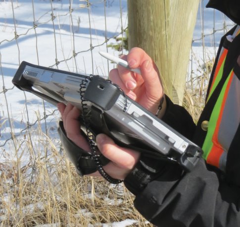
Tablet computers with global positioning System (GPS) capabilities were used to collect data and asset photos.
Geo-referenced route photos were automatically captured by dashboard cameras. The data was delivered using Vertisee, McElhanney’s in-house, web-based mapping software that combines GIS with maps.
Despite the presence of all the advanced technology, the data had to be collected the old-fashioned way.
More than 80 McElhanney employees, most of whom didn’t have a background in GIS, were dispatched to the field with digital devices.
"To make it easier for them, we developed a customized interface for Vertisee, so that they didn’t need a lot of training to collect and deliver the data," said Walashek.
McElhanney’s custom mobile GIS solution is an advancement over earlier technologies, Walashek said.
"The massive amounts of data used to be presented in cumbersome spreadsheet formats, among others," he said. "The mobile GIS enables the data to be searched for, filtered and displayed quickly and easily in an intuitive online map that users can access anywhere and anytime."
Most of the time the data was collected and displayed within 24 hours.
"Neither McElhanney nor the client had achieved that kind of speed and efficiency before," said Walashek.
Without the custom mobile GIS, data describing the access network would have had to have been collected using old survey and data collection methods, and a multitude of logbooks, cameras, GPS devices and paper maps. Not surprisingly, the project was anything but simple and straightforward.
"Massive amounts of data needed to be collected over a 650 km pipeline corridor and 2,000 km of roads," said Walashek.
"Traditionally, this would have taken a lot of manpower and hours to collect, and a very long time to sift through after collection."
Although advanced technology was necessary to the success of the project, there is a limit to the usefulness of high-tech – in the form of drones, for example – in gathering and presenting the data.
"You still need people on the ground who can do the collecting," Walashek said.
"Drones with cameras can be operated to collect some features, but they can’t do assessments or take measurements and perform detailed on the ground analysis."
Data collection in the project took place during the summers of 2013 and 2014, and the analysis took place between 2013 and 2015. TransCanada took the data and used it to calculate cost estimates for each bridge and culvert upgrade.
"The pictures, assessment details and cost estimates to upgrade each structure were loaded to Vertisee," said Greg Cano, director of project planning and execution for TransCanada’s Coastal GasLink Pipeline.
"Cost estimates for each road upgrade and associated structure upgrade were then evaluated for the perceived benefit that road contributed to the overall Coastal GasLink construction access network."
If the upgrade costs exceeded the anticipated benefit of including a road in the construction access network, the road was dropped from the network.
"In addition, the mapping allowed the potential construction access roads to be evaluated with respect to proximity to residences and other developments," Cano said. "Some roads were dropped as construction access to mitigate effects on landowners or other stakeholders."
Before it can go ahead, the LNG project needs to receive permits from the BC Oil and Gas Commission and a positive final investment decision (FID) from LNG Canada, the proponent of the facility. McElhanney is a surveying, engineering and mapping company with 22 offices in B.C., Alberta and Saskatchewan, including headquarters in Vancouver.
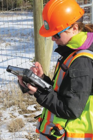
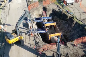
McElhanney Consulting Services Ltd. has built a custom mobile geographic information system (GIS) app for a possible liquefied natural gas (LNG) pipeline built by TransCanada Pipelines Limited.
Photo: McElhanney Consulting"


Recent Comments
comments for this post are closed