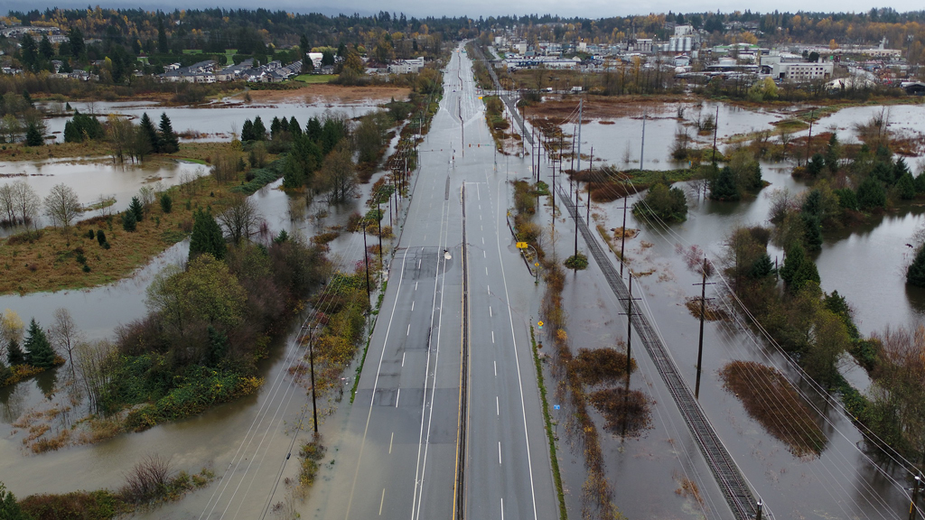
As B.C. picks up the pieces following a brutal stretch of rain and wind, scientists are looking into what the events mean and how the region can better prepare for the future.
Simon Donner, a climate scientist who teaches at UBC, explained while B.C.’s recent weather is freakish even in the context of a changing climate, it still is giving a preview of future conditions.
Donner said this year’s La Niña weather pattern meant more severe weather was expected, but not this severe.
“You tend to have wetter winters during La Nina and we tend to get a few more of these atmospheric river events but this particular one looks just record shattering,” said Donner, noting that Hope, B.C. saw 250 millimetres of rain in just a few days.
“Those totals are more like what you would see out of a tropical cyclone, but it’s in November. In Canada.”
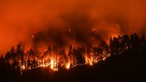
Donner said rain fell intensely for long periods of time on soils and rivers already saturated from early winter rains. This was also on areas already hammered by wildfires and record breaking summer heat.
“We were kind of set up for a disaster,” said Donner. “Both these extreme events – the heat dome in the summer and the incredible atmospheric river this fall – they both have all of the characteristics we expect to see as the planet gets warmer. A warmer atmosphere can hold more water. That is fundamental physics. We expect that as the planet gets warmer, the average rainfall might not go up but extreme rainfall should go up. So the distribution is sort of changing.”
However, Donner said even with a changing climate, events like the summer heat dome are so rare, scientists are unsure how to even generate what their statistical likelihood is.
“B.C. has just been ground zero this year,” said Donner. “We have been getting this incredible preview of the future. However, this doesn’t mean we will have heat domes every summer, and it doesn’t mean record flooding and rainfall every year either.”
But it does mean more extreme weather, especially more snow that turns to rainfall at higher elevations, which Donner says means more flooding at odd times during the year.
He believes the federal and provincial governments need to update floodplain maps and planning standards.
“Any planning you do for building in areas of low elevation, near the coast or close to a floodplain, there is always this question of what your planning standard should be,” said Donner. “Are you building for a 100-year flood or 200-year flood? We can do the statistics for those things. The problem is we are basing what we call a 100-year flood on an old climate. The climate has changed and it’s continuing to change unless we dramatically reduce greenhouse gas emissions.”
Donner added when communities like Lytton are destroyed, there is an opportunity to rebuild with resiliency and reduced greenhouse gas emissions in mind.
“When we have to rebuild after a disaster, as horrible as it is, there’s an opportunity to build something that isn’t just adapting to the climate of tomorrow, but is also contributing to reducing climate change,” he said.
Many of the province’s key highways were cut off in the aftermath of the storm from flooding or mudslides.
Brett Gilley, a geology expert at UBC, explained wetter winters present a particularly difficult problem for roadbuilding.
“The one that is most alarming to me is these landslides,” said Gilley. “Because we are in a mountainous area, we have a risk of landslides anywhere. And these debris flows are particularly tricky because the whole area that the creek drains above the road will be the drainage basin that is affected and any landslide that starts in that area, if it is big enough, will pick up tricks and eventually get down to the creek. Then you have this wall of rocks and trees and mud and water ripping down and that is what tends to take out those bridges.”
He explained B.C.’s recent hot summers have damaged root systems and wildfires give areas a much higher risk of slides for decades.
“I am worried that this is a new normal, that we will see more and more events like this where multiple things pile on together,” said Gilley. “What we have to start to look at is how we are going to deal with this, because we have to have roads through the mountains and that is a hazardous area.”
He explained simply moving routes is not only extremely expensive, but most areas have similar terrain, meaning the risks are essentially the same. However, things can be done to bolster existing routes.
“It is too much to do all at once,” said Gilley. “There is no way we can stabilize every slope in the province. So what they tend to do is pick and choose with their limited resources where they are going to work on stuff.”
He highlighted work done on Highway 99 in preparation for the 2010 Olympics as a key example of targeting high risk areas for improvement.
“We spent a lot of money on that road,” said Gilley. “That was a much more dangerous road before and it’s a good example of a place where a lot of engineering has been done.”
Follow the author on Twitter @RussellReports.


Recent Comments