After three years of heavy rainfalls and spring floods, Greg Bruce and his team are planning for ways to make B.C.’s road system more resilient to extreme climate events.
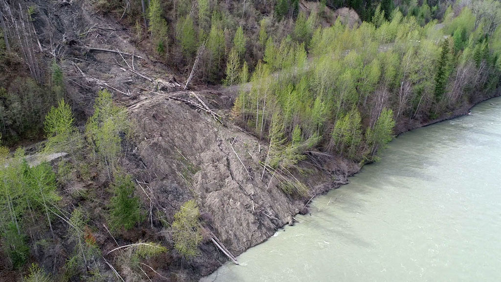
Bruce, an employee with the BC Ministry of Transportation for more than 23 years, is the leader of the Cariboo Road Recovery Project, a large undertaking to repair and reopen 10 roads along the Cariboo Road from just north of Quesnel down south to Williams Lake which have been partially destroyed due to landslides between 2019 and 2021.
Of the 10 roads under Bruce’s purview, four are still closed but alternative access routes or one-way through roads have been created. Bruce and his team have spent more than a year researching and collecting data so they might plan and understand the causes and calling signs of landslides in B.C.
Major reconstruction has not yet started, he said.
Bruce’s project may be focused on the roads branching off Cariboo Road but the work he and his team are doing directly builds into the larger infrastructure goal of learning how roadways can be made more resilient.
“The Cariboo Road Recovery Project is working to improve resilience in two ways,” he said.
“Determining how to address the vulnerability of each project site and also looking at the broader corridor and working with the rest of our ministry to determine where other areas of vulnerability exist.”
Data collection is essential in understanding and monitoring the topography of B.C.’s hills and mountains to mitigate future destruction.
Bruce is working with the Pacific Climate Impact Consortium, using their data to understand specific weather events and sharing his project’s information with the organization.
Building to handle climate change means forming a clear picture of where the climate is going in the next 10 to 20 decades, let alone over the next 10 years.
In engineering and infrastructure design, many projects are made to withstand a 100-year climate event. But this model is changing as the intensity and frequency of climate events increases.
“The 100-year event became a 25-year event which then, who knows, maybe it’s even less than that (now),” said Bruce.
“We started designing out to a 200-year event. Now we’re getting more detail and looking at how to forecast those events and make sure that we’re constructing appropriately.”
Bruce and his team are using state-of-the-art technology to gain that knowledge.
“Landslides are complicated. They require extensive investigations and analysis.”
One such technology is laser imaging, detection and ranging, or LiDAR.
“We run LiDAR surveys regularly. What it does is it’ll also show you the changes in ground movements,” he said.
“If, for example, if you have a slide run out and there’s an accumulation there, it actually captures that. It’ll actually show you in a colour spectrum where the ground drops and where it rises.”
Bruce has also installed fixed electronic surveys in areas which measure the stability of the land 24/7.
Things that we expect to see is certainly upsizing culverts, bridging areas of concern where culverts are no longer suitable and redesign of drainage channels for better flow,
— Greg Bruce
BC Ministry of Transportation
“If a piece of ground moves, we’ll be aware of it immediately. We have alarms essentially set up so we can know if something moves.”
Through extensive drilling, the government has set up a network of monitoring systems to know when and where ground shifts are occurring. This is especially important when dealing with landslides as the ground can remain unstable for years after the landslide is triggered.
“It’s adding more science to the decision-making process. Forecasting for those events isn’t actually something that we’ve done before.”
While the technology used to collect data can be extremely high-tech, the best solutions can often be tried and true construction methods.
“Things that we expect to see is certainly upsizing culverts, bridging areas of concern where culverts are no longer suitable and redesign of drainage channels for better flow,” he said.
“Armouring of slopes — very typical solutions that you probably see on the roadside, even — to provide long-term resilient solutions.”
Bruce says B.C. has been planning around climate events for many years.
“This isn’t a radical shift. The first pilot that we went through, we didn’t actually see a significant change in the design. The criteria that we’re already using has captured a lot of what already came through that review.”
“I’d say that (the data) confirms for the large part that we’re already in the right place.”
Bruce gave insight into the major causes of landslides around the Cariboo Road and across B.C. in the past few years.
“One was a typical freshet event where it was intense rainfalls and snow melts and lots of road washouts,” said Bruce.
“There was also a segment that was the result of increased water pressures in in the soil. Most of our projects are that second piece.”
Bruce said more than 250 sites were impacted by freshet events between 2019 and 2021, which includes anything from a curb being washed out to a major highway closure.
But the Cariboo Road project is made up entirely of roads washed out due to increased water pressure in the soil built up over several months.
What Bruce described was a multi-season buildup of water due to climate events. He said heavy rains in the fall of 2019 were rapidly frozen by cold weather in winter, meaning the water stayed in the soil and did not evaporate.
Then in the Spring of 2020 there was more heavy rain combined with a significant thawing of all the frozen rainwater trapped in the soil from the previous year. This buildup and sudden release causes landslides. A similar series of events occurred again in 2021.
“What happened is these 10 areas that we’re dealing with saw really accelerated movement and significant impact,” said Bruce.
“We had landslides across the road, that sort of thing.”
The various roads included in the project are all in different stages of use. The Quesnel-Hydraulic Road has only recently had a one-way gravel road opened through the landslide, Bruce said.
The Cariboo Road project is still in a “multi-phase technical driven process,” said Bruce.
The scale and sudden onset of destruction that comes from atmospheric rivers, freshet events and water-pressure buildups mean the ministry relies on a blend of in-house staff, contracted workers and consultants to get the job done.
“The consulting support gives us that flexibility to ramp up like we need to right now and then ramp back down,” said Bruce.
Currently the ministry is working with Stantec Inc. on the Cariboo recovery.
Bruce was hesitant to put a date on when construction may begin, but he said some designs are being finalized and will be posted to the projects website once they are confirmed.
“Our effort is to expediate this. These are landslides that are active as we speak. So, there’s a real urgency with these and they’re each unique.”
Follow the author on Twitter @JOC_Evan.

Recent Comments