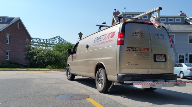
Vans equipped with sophisticated sensing equipment are the latest tool municipal engineers can use to assess the condition of pavements.
The technology, brought to market by a Massachusetts start-up called Streetscan, was developed during a multi-year research project at Northeastern University in Boston. The project was part of the technology innovation program run by the U.S. National Institute of Standards and Technology.
It was a result of persistent worries about the state of American road infrastructure.
The research project, called VOTERS, for Versatile Onboard Traffic Embedded Roaming Sensors, developed a system of multiple sensor subsystems to obtain measurements and data using a variety of methods. They included measuring acoustic waves generated by tires during normal driving, high-frequency impulse radar to detect subsurface delamination and corrosion, millimetre-wave radar to determine the near-surface properties of pavements and full-field optical profiling to detect surface irregularities and build a profile of the pavement’s running surface.
VOTERS involved a team of more than 40 researchers, graduate students and joint-venture partners from both the business world and academia and lasted five years.
Ralf Birken was a research professor at Northeastern U, and worked on the VOTERS project. But he has since left the academic world to join a spinoff company called StreetScan, where he is both chief operating officer and chief technology officer. He’s no stranger to commercializing new ideas while working in the private sector.
"I’d been involved with a startup before I joined Northeastern," he said in a recent interview. "I’ve always liked the entrepreneurial side of bringing a small business up and trying to have some success."
StreetScan isn’t a year old yet, but it already has completed seven pavement-assessment contracts in Massachusetts and one in New Hampshire. It has more contracts in hand waiting for spring, when pavements are clear. One of those involves sending a van across the country to scan all the roads in the Washington State parks system.
Technologies that have emerged in recent years are central to the system devised by VOTERS and now being commercialized by StreetScan. Sensors play an important part, as do modern variants or radar.
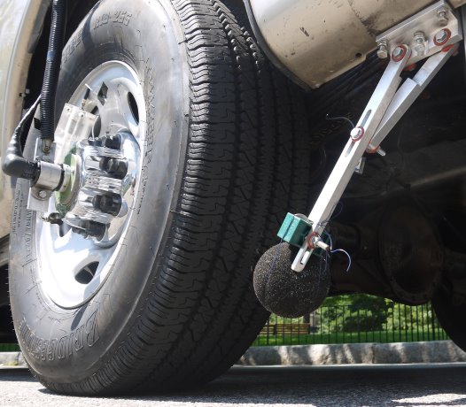
For example, the system uses millimetre-wave radar, which is used by the military for fire control. It is a short-range system and its high definition is capable of detecting bullets in flight. The StreetScan system uses it to measure the depth of any rutting, as well as mapping surface defects and features such as potholes, water, manhole covers or stormwater grills.
The VOTERS system also utilizes ground-penetrating radar, a geophysical tool that uses radar pulses to generate images of what lies beneath the surface. It can detect changes in material properties, voids and cracks. Thus, it’s able to detect corrosion of rebar or delamination in bridge decks.
Using acoustic technology, the system uses vibrations and sound waves induced by car tires to determine the texture of the road’s running surface and its overall condition. That’s why the vans carrying the VOTERS scanning system have microphones mounted close to the vehicles’ rear tires. StreetScan augments the system by using a tire pressure sensor.
There’s even a video camera which photographs surface defects for verification of results from the other systems and helps with the assessment of the types and severity of cracks.
Birken said that in use, the system is simple. The van is just driven along every lane of every road in the study area. Although meaningful data can be collected at highway speeds of up to 60 mph, traffic flow means the average speed for a survey is much slower.
In a job last autumn in the town of Littleton, Mass., 62 miles of roads were scanned in two half days.
"There were 10 hours of survey time and the average speed was 17 mph. We drove every lane of every road in the municipality, which meant the 62 miles of roads translated into 170 lane-miles," Birken said.
Each such job generates immense amounts of data, which is analyzed and within days, the client receives a pavement condition map that, together with system’s pavement managing toolbox, helps municipal engineers and other decision-makers formulate strategies for maintaining and improving their road network.
StreetScan so far is limited in its reach to New England and by the fact that it has only two vans. But, Birken said, they’re planning to outfit two more vans, starting within weeks. They’re also looking for companies to act as licensees, to do the scans in other parts of the country "or even internationally, if the opportunity comes up."
Another idea, farther in the future, is to develop "a subset of our sensors and package them in a way that you could attach them to fleet vehicles."
"It could be taxicabs, UPS trucks, public works cars, police cars, just fleets of cars that are driving around the city anyway. This would be a scaled-down version. We would take one or two key sensors, one of them being the surface radar system."
The data could be collected by a computer sitting in the trunk.
How soon might this happen?
"I’d really like to have this ready for deployment in six or nine months," Birken said.


Recent Comments
comments for this post are closed