Construction along the St. Lawrence Seaway in the 1950s resulted in the loss of a part of Canadian history.
It also resulted in a rewriting of the federal-provincial expropriation legislation and regulations on minimum space between buildings written into the National Model Building Code.
The loss of history was the flooding of what has become known as the "lost villages," or "the Old Front"— nine small communities originally established by United Empire Loyalists in 1784 after the American war of independence.
They were the villages of Milles Roches, Moulinette, Dickinson’s Landing, Wales, Farran’s Point and Aultsville, and the hamlets of Woodlands, Santa Cruz and Maple Grove. Many residents of the villages were descendants of those first Loyalist settlers.
More than 500 of the buildings were moved to the new towns of Ingleside and Long Sault. But some were left to disappear beneath the rising waters of Lake St. Lawrence.
That lake is actually the head pond for the Saunders/Moses Power Dam across the St. Lawrence River between Cornwall, Ont. and Massena, N.Y. The dam was the hydroelectric power element of the seaway project and supplies power to both Ontario and New York State.
Work on the project began in the summer of 1954 and was completed on time for the beginning of operations on July 1, 1958.
It was a big project and it affected thousands of people.
The villages flooded lay along the north shore of the river west of Cornwall. That meant the relocation of about 6,500 people, most of them village residents. Others were farmers in the area. More than 8,000 hectares of farmland and mature orchards were inundated.
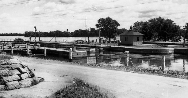
Creation of a new shoreline meant that the village of Iroquois — the whole village — was moved 1.6 kilometres north. The village of Morrisburg lost its original main street and business district. But at least those villages remained.
Railway lines and highways had to be moved. The old Grand Trunk Railway between Montreal and Toronto ran through the area, so 64 kilometres had to be removed and rebuilt on a new alignment to the north. Fifty-six kilometres of Highway 2, the main east-west route in the area, was also rebuilt to the north. The old road was simply flooded over and parts of it can still be seen under the water.
There were 18 small cemeteries in the area, and only one was moved in its entirety. It stood in the way of the dam construction. As for the others, graves were moved only when families asked, or if they were recent. Those that were left behind were covered with limestone or large stone slabs to prevent water erosion.
Relocating the houses was itself a big project. The Hydro-Electric Commission of Ontario retained the Hartshorne House Moving Co., from New Jersey, to do the work. The company brought with it two large moving machines capable of picking up and moving houses and placing them, intact, on the foundations waiting for them in one of the new towns.
Through all this there was an undercurrent of unrest. People whose homes had been expropriated were offered two choices. They could choose from replacement homes, or they could receive market value plus 10 per cent for the homes they were losing.
Neither choice was acceptable to many. The replacement homes were criticized as "chicken coop" houses. The cash offer was considered too low because land in the planned flood zone had been devalued for several years because of the coming of the seaway. That meant market value wasn’t enough to replace homes.
By late 1954, the Hydro-Electric Commission of Ontario was offering the option of moving existing homes at no cost to the homeowner and placing them on free lots with foundations already installed.
House moving began in the spring of 1955 and ended early in 1958.
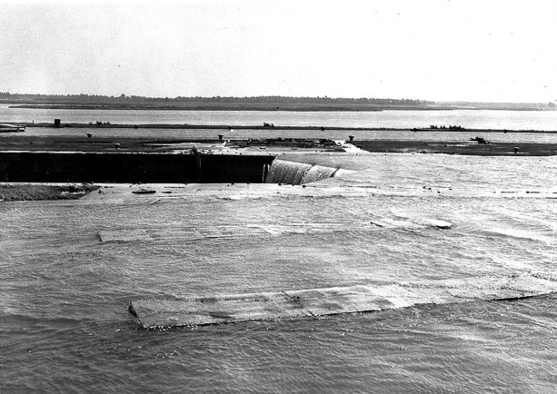
Finally, on July 1, 1958, all was ready. Hydro had set 8 a.m. as the time for the explosive demolition of the last cofferdam. Crowds of people turned out to watch.
The blast came just one minute late, the cofferdam was destroyed, and water began to flood over 160 square kilometres of farmland behind the new powerhouse. The water level rose steadily for four days before it stabilized.
The experiences of those villagers highlighted outdated laws governing expropriation in Ontario, especially the power they allowed the hydro commission over the public. A provincial committee reviewed the process of expropriation in the province and recommended that power to take possession of land without formal notice or consent of the landowner should be allowed only with the approval of the Ontario Energy Board. Expropriation laws were changed in the 1960s to bring all pertinent laws together under a single act. And by the end of the decade, the federal Expropriation Act, which had been unchanged since 1886, was also reformed.
While all this was going on, there was another project underway. It became known as the St. Lawrence Burns, and it involved the deliberate burning down of six buildings in the village of Aultsville, which would later become one of the lost villages.
The burns were carried out in January and February 1958, by the National Research Council’s (NRC) Division of Building Research, the forerunner of today’s Institute for Research in Construction.
The reports of what was learned during those burns are in the NRC’s archives.
A summary report said the main object was "to study the development of fire in dwellings with regard to the limiting time of survival of the occupants, and to the likelihood of spread of fire to neighbouring buildings."
The buildings selected were rigged with what was, for the time, sophisticated instrumentation. And the fires were started.
Key among the findings was the fact that radiant heat, and not convection, created the greatest danger of fires starting in nearby buildings. These results led to regulations regarding minimum space between buildings, regulations that were incorporated in the building code.
There was a sad irony in the St. Lawrence Burns.
Ernest Gillard, who had been volunteer fire chief in Aultsville, watched several of the fires, including the burning of his own house. The experience, he said, was "devastating."


Recent Comments
comments for this post are closed