The governments of Canada, Ontario and Toronto have announced $1.185 billion in funding for flood protection of the Toronto Port Lands, a precursor stage to developing a significant new mixed-use neighbourhood on the city’s east waterfront.
Prime Minister Justin Trudeau, Ontario Premier Kathleen Wynne and Toronto Mayor John Tory joined Waterfront Toronto CEO Will Fleissig at a noon-hour ceremony June 28 to announce the funding. The Government of Canada will contribute $384 million to the project and Ontario and Toronto will each give $400 million.
The Port Lands Flood Protection project will take approximately seven years to complete and will be delivered by Waterfront Toronto.
A statement from Waterfront Toronto quoted a third-party economic impact study that estimates spending on construction alone will generate approximately $1.1 billion in value to the Canadian economy and create 10,829 person years of employment.
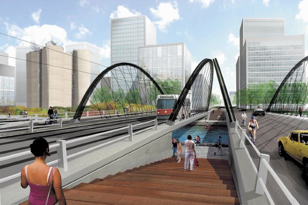
The Port Lands Flood Protection project will create two new outlets for the Don River, including a wide new river valley, that will steer flood waters into Lake Ontario, as well as provide new parks, aquatic habitat and infrastructure such as roads, bridges and a transit right-of-way. It will also help clean up contaminated soil and prepare land for development, said media statements from the partners.
Trudeau explained the dual purpose of the new spending in remarks delivered on the east Toronto waterfront.
Will Fleissig
Waterfront Toronto
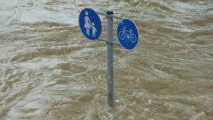
The first is resilience, he said — to protect the lands from flooding during major storms. Flooding in the Don Valley shuts down GO trains and homes are damaged beyond repair.
"We need to take steps now to ensure the lands we are gathering on can be used and enjoyed for decades to come," said Trudeau.
The climate change remediation measures also unlock economic potential, he said.
"It is not going to be able to be fully developed until it is cleaned up and flooding protection systems are put in place," he said. "Fifteen-hundred jobs will be created during the cleanup and development phases and 80,000 jobs located in the east harbour area upon completion."
Trudeau said over 12-million feet of new commercial development space will be added to Toronto’s downtown once the project is completed, and 30,000 units of new housing will be built.
Wynne called it the greatest new source of developable land in the downtown of any city in North America.
Last September early-phase funding was announced, with the three levels of government pledging $65 million in infrastructure spending under the Clean Water and Wastewater Fund for the Cherry Street Storm Water and Lakefilling project, which is included in the $1.185-billion cost, Waterfront Toronto explained.
In his remarks, Fleissig acknowledged collaboration in planning for remediation of the Port Lands going back to 1991 and recognized the ideas generated by the Lower Don Lands Design Competition a decade ago.
Fleissig credited Michael Van Valkenburgh Associates (New York), Behnisch Architects (Los Angeles) and Ken Greenberg (Toronto) with recommending retention of the Keating Channel and adding a second waterway to the south.
"Flood protecting the Port Lands presents us with a once-in-a-lifetime opportunity to imagine and create a prosperous, inclusive, sustainable community right at the doorstep of downtown," said Fleissig.
He said the timeframe for the development of parks, infrastructure and the multi-use developments that will follow is the next six, seven or eight years but in the meantime there will be significant new development in the vicinity within the next two to four years.
He said thanks to ongoing Waterfront Toronto revitalization efforts, including partnerships with the City of Toronto and the Toronto and Region Conservation Authority, there has already been $10 billion in private investments.
"As you can see right behind us, the fruits of that partnership are the cranes that you see building in the east bayfront," he said. "Since 2001 that view has changed, transforming an underused industrial parkland and parking lots into high-quality sustainable neighbourhoods.
"There will be continuous market development. We know that the development is coming east, it will continue on the east bayfront area and then roll right into Villiers Island."
Tory said the government investment will help the City of Toronto meet its obligations under its TransformTO program, initiated in two stages starting last December, setting targets of a 30-per-cent reduction in GHG emissions by 2020 and 80 per cent by 2050.
Port Lands protection: What will $1.2 billion buy?
TORONTO — There are four main components to the Port Lands Flood Protection project as outlined by the Province of Ontario:
• Earthworks. This component will include 1.5-million cubic metres of excavated soil, additional soil remediation and the handling and placement of excavated soil required to implement grade changes and create over 1,000 metres of naturalized river valley, a new greenway and a sediment management area north of the Keating Channel.
• Roads, services and utilities. This part of the build involves the installation of new municipal infrastructure including watermains, wastewater and storm water sewers. It will also involve the creation of roads and a transit right-of-way and the relocation of hydro utilities.
• Bridges and dockwall structures. This component will include the design and construction of three new bridges and the extension of the Lake Shore Boulevard Bridge to create a wider opening over the river. Dockwalls will also be modified and created.
• Parks and naturalized areas. This component will create 29 hectares of new naturalized area in the river valley, including 14 hectares of aquatic habitat, plus an additional 16 hectares of new parkland. Also included is the construction of trails, boardwalks, overlooks, a small boat launch and fishing sites within the floodplain area.


Recent Comments
comments for this post are closed