Imagine that you could look at a map displaying almost every capital infrastructure construction project, particularly those involving road work, currently taking place in Toronto.
Now imagine that you could project that map forward in time to see every similar project planned in the city for the next five years.
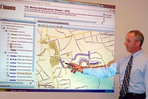
That’s the grand vision of Jeffrey Climans, director, Major Capital Infrastructure Coordination (MCIC) with the City of Toronto. MCIC has already developed and launched the inaugural version of T.O. INview (short for Infrastructure Viewer), a web-based mapping system that currently enables users to quickly identify different types of construction occurring across the city in 2012. Projects appear as coloured layers that differentiate, for example, between road, sewer, water, utility, TTC and Metrolinx projects. By hovering over a project, users can access specific project details.
On the face of it, the system offers residents a way to inform citizens and provide them with a way to plan their travel around various road restrictions. That’s only the tip of the iceberg. The system will also be used to improve coordination of projects, with the goal of more efficient capital expenditures and reduced inconvenience to the public.
“We now have better opportunities to piggyback sewer and water projects that might involve repaving, with planned road construction work, for example, so that we’re only digging once and repaving once,” says Climans. “If a private utility wants to install a fibre-optic cable upgrade in a specific neighbourhood, they could look at the website and determine that the roads and sidewalks will be torn up in a particular area at a certain time and install them then.”
Users can display all construction layers, or a combination of layers. Each of the layers provides more definitive detail as well. Under “transportation services” alone, for example, users can choose among six sub-layers that include road resurfacing, road reconstruction, new sidewalk construction, bridge work, street furniture and areas under a five-year construction moratorium.
T.O. INview is an extension of a printed document that attempted to provide similar construction data. However, that document took considerable time to prepare and print, and individual projects were then subject to budget approval by city council.
“By the time everything was finalized, the printed version didn’t have a lot of useful life left,” says Climans.
The web-based successor was devised and launched entirely by in-house staff, at no additional cost to taxpayers.
“We chose not to involve a consultant because we realized it would require a significant effort just to get the consultant up to speed on what we already knew,” he says.
MMIC’s ambitious plans include the ability to project construction information five years into the future, allowing the user to access construction projects by type, and by year.
“With that sort of lead time, we might not see every project that will happen, but we can plan projects based on what we know is planned,” Climans says. “If we know there will be road work in 2013, perhaps we can accelerate a sewer project planned for 2014, or move the road work to the next year.”
The five-year system prototype is being prepared for launch, but is already being used in-house to plan significant road construction work around the 2015 Toronto Pan Am Games.
“We’re trying to ensure that any significant road, sewer and water work will either be slightly accelerated or delayed so that it doesn’t affect the movement of traffic during the event,” says Climans. “As a side benefit, it will also make the city more photogenic during the sporting events.”
While Toronto agencies will be required to submit their projects so they can be reflected in T.O. INview, other utilities are beginning to participate in the system voluntarily. The map includes project data submitted by Cogeco, Enbridge, Hydro One, Rogers and Toronto Hydro.
One feature of the system will change the way that citizens understand city projects. Each information box associated with a project will feature the name and phone number of the project supervisor and provide a link to e-mail that person directly.
“Staff members were very receptive to the idea,” says Climans. “By being visible to the public it may be possible that there will be a greater sense of urgency to get a project finished on schedule.”
Recent Comments
comments for this post are closed