This is the first in a two-part series on a massive project taking place in the Port Lands area of Toronto to transform underused land and protect the southeastern part of the city from flooding.
A rock truck and bulldozer are parked side by side at a sprawling construction site in the Port Lands area of Toronto, partially obscured by large mounds of brown soil.
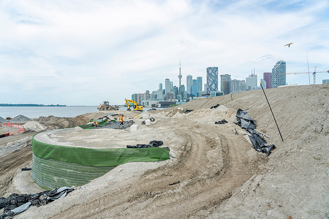
Grey armour stone has been placed strategically across the landscape and, in the distance, one can see the iconic CN Tower and several skyscrapers.
Normally, the site is a beehive of activity. But it’s the weekend and the venue is strangely silent. A seemingly endless number of tire tracks from heavy equipment etched in the dirt are the only signs of life.
The site is part of the $1.25-billion Port Lands Flood Protection Project (PLFPP), a venture that was first envisioned back in the late ‘80s. Today, it is one of the biggest infrastructure projects in Toronto’s history.
The venture requires excavating, moving and placing more than 1.5 million cubic metres of soil and fill — enough to fill the Rogers Centre.
“Port Lands flood protection is a comprehensive solution to flood protection that also addresses the fundamental challenge of transforming the underused and post-industrial Port Lands into a long-term asset that will support Toronto’s growth and economic competitiveness,” explains Don Forbes, project director, soil remediation and earthworks at Waterfront Toronto, which is leading the development project.
In addition to flood protection measures, the project will create a new mouth for the Don River in the middle of the Port Lands between the Ship Channel and the Keating Channel, as well as the foundations of a new urban island neighbourhood called Villiers Island.
“It will also create new natural habitats and re-establish wetlands in the area, which provide social and environmental benefits and naturally moderate the effects of flooding and erosion,” says Forbes.
“Naturalizing the mouth of the Don River will provide the necessary flood protection and unlock the development potential of this premier waterfront area.”
After many years of extensive planning and consultation, construction on the behemoth project began in December 2017.
The Port Lands is a 400-hectare parcel of waterfront land bounded by the Keating Channel/Don River and Lake Shore Boulevard, Toronto Inner Harbour, Ashbridges Bay and Lake Ontario and Tommy Thompson Park.
The project is being undertaken to protect about 290 hectares in Toronto’s southeastern downtown area from flooding.
In extreme weather events, floodwaters from the Don River can overwhelm portions of the Port Lands, South Riverdale and Leslieville.
The Port Lands area sits within a designated floodplain, which is an area that hydraulic modelling demonstrates will experience flooding in the event of a regional storm.
Providing flood protection for the Port Lands was identified as a top priority by all three orders of government when they first established Waterfront Toronto in 2001.
The area was created by decades of infilling what was once one of the largest wetlands on Lake Ontario. Beginning in the late 1800s, the area was gradually filled in to make more land available for industry and shipping.
As the natural mouth of the Don River was filled in, the Keating Channel was created to provide an outlet for the Don River watershed into Lake Ontario and a means to convey storm water.
If all goes according to plan, the project will be complete by the end of 2024, with parks fully opening in 2025.
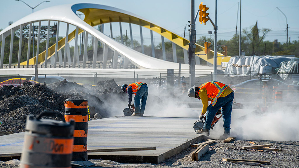
The PLFPP includes a variety of separate projects such as excavating the river valley and remediating contaminated soil, creating new grading around the river’s banks, building parks, infrastructure, new bridges, wetlands and structures and features that allow for conveyance and control of storm waters. Roads in the area are being rebuilt and sections of existing streets and trails and bike paths have been realigned.
Crews are presently working on excavating sections of the river valley, installing a special river liner and underdrains, planting in the river valley and surrounding wetlands, earthworks and utilities installation in the parks, and paving and utilities work along rebuilt roads, namely Commissioners Street and Cherry Street.
Meanwhile, workers are digging a new mouth for the Don River where it flows into Lake Ontario. It will be between two to three metres deep. A cut-off wall was built to keep the river valley dry during construction. When the river valley is complete the wall will be removed to allow the river waters to flow.
With the site’s legacy of being used for industrial purposes, a challenge has been dealing with contaminated soil and groundwater.
“The Port Lands were created through the placement of low-quality fill on top of the lake bed and marsh deposits, so remediating the soil and stabilizing it to support the parks, roads and infrastructure has been a big part of the project,” says Forbes.
The cost of the project has risen substantially from its original budget estimate in 2016, in large part due to inflation and external factors such as supply chain challenges exacerbated by the COVID-19 pandemic.
However, Forbes notes the increase is less than the norm for other projects.
“To put that 13 per cent to 15 per cent in context, in 2022, the cost to deliver non-residential construction projects in Toronto was 49.6-per-cent greater than in 2017.”
Tomorrow’s story will focus on novel construction work being done to create a new mouth for the Don River.
Port Lands deep dive: Creating a new mouth for the Don River
Recent Comments
comments for this post are closed