An environmental research team from Wilfrid Laurier University is helping to secure safer winter roads for an isolated community on Great Bear Lake in the Northwest Territories, and is in turn benefiting from unique local knowledge.
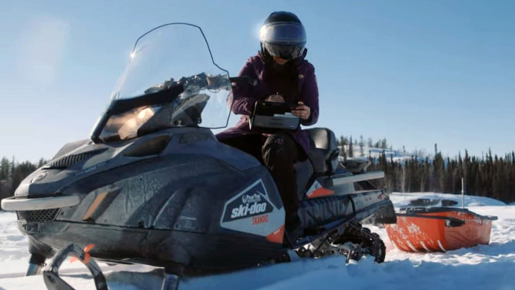
For four years Homa Kheyrollah Pour, the Canada research chair in remote sensing of environmental change at Laurier, and colleagues have flown into Deline, N.W.T., 544 kilometres northwest of Yellowknife, to employ multiple devices to gather data on the ice, snow and waters of Great Bear Lake. Tools include radar from the European Space Station’s Sentinel satellite, air and underwater drones, strings of surface temperature sensors and ground-penetrating radar.
Kheyrollah Pour, who has a math background, is working to develop mathematical and machine-learning models to understand the changes happening to northern lake ice, water quality and land cover.
“The challenges are getting complex,” said Kheyrollah Pour. “Not only, for example, is temperature rising, but precipitation is changing, evaporation is changing, everything is changing at the same time.
“So there is not an easy challenge that one discipline can solve. We definitely need to bring different disciplines to solve this complex issue.”
Deline is a fly-in mostly Indigenous community of about 600 that relies on the winter road season from January to April to obtain critical supplies.
Chief Danny Gaudet has been building winter roads for 30 years, with thousands of holes drilled to test ice thickness over the years until the arrival of the team from Laurier to offer support. The ice roads must be able to support 60,000 kilograms of weight.
The climate is changing drastically, said Kheyrollah Pour.
“One example is the water level. It’s declined drastically and one of the effects for the community is boating. I was there in August, where they have their traditional fish camp every year, and it was hard to actually move people to the camp because the water level was so low.”
One change affects the whole ecosystem, Kheyrollah Pour said. With the ice forming later and melting earlier, there is a longer season for open water, extending the length of time the water gains sun energy, which changes the temperature of the water – including each layer of water. Thus the regular cycle of cold water sinking to the bottom and warm water rising to the top is affected, so the overall accumulation of oxygen throughout the lake is distorted and there is hypoxia, an absence of oxygen that affects the plant life.
Meanwhile, the permafrost is melting, sending more carbon into the lake and affecting the level of nutrients. The visit by Laurier researchers last August included a focus on water quality, including evaluation of the water from the community’s water treatment plant.
“We’re not only focusing on ice, we’re also focusing in the summertime on how the whole system might change in terms of the quality of the water and ice,” explained Kheyrollah Pour.
The exchange of local knowledge is often done orally over a pot of tea, Kheyrollah Pour said.
“I need their land information. I need their traditional knowledge to understand where I can install my sensors,” she said, citing on example.
When the Laurier team needs to crack open the ice to dispatch an underwater drone, they may consult with the locals to find the thinnest spot for easiest access. There are also discussions about changes in ice over time, with a Laurier scientist showing SAR images from the Sentinel satellite and receiving input about different types of ice.
The western scientific methods include using the ground-penetrating radar systems pulled by snowmobiles to gather data. Local “guardians” are gaining expertise such that they are now helping to install the sensors. Local workers are also capturing drone imagery.
Eventually local knowledge and western research methods will mesh.
“They do have the traditional knowledge,” said Kheyrollah Pour. “And we can actually teach them the western science technology, which they are very much interested in. So we can actually create more local scientists. That’s my next goal.
“And I started to talk with the local school on how we can bring more people, how we can bring more youth, into this.”
The exchange is about more than science, she said.
“It’s also your own growth as a human. I learn a lot every time I’m in the community.
“You learn to really take care of your environment.”
Follow the author on Twitter @DonWall_DCN.
Recent Comments