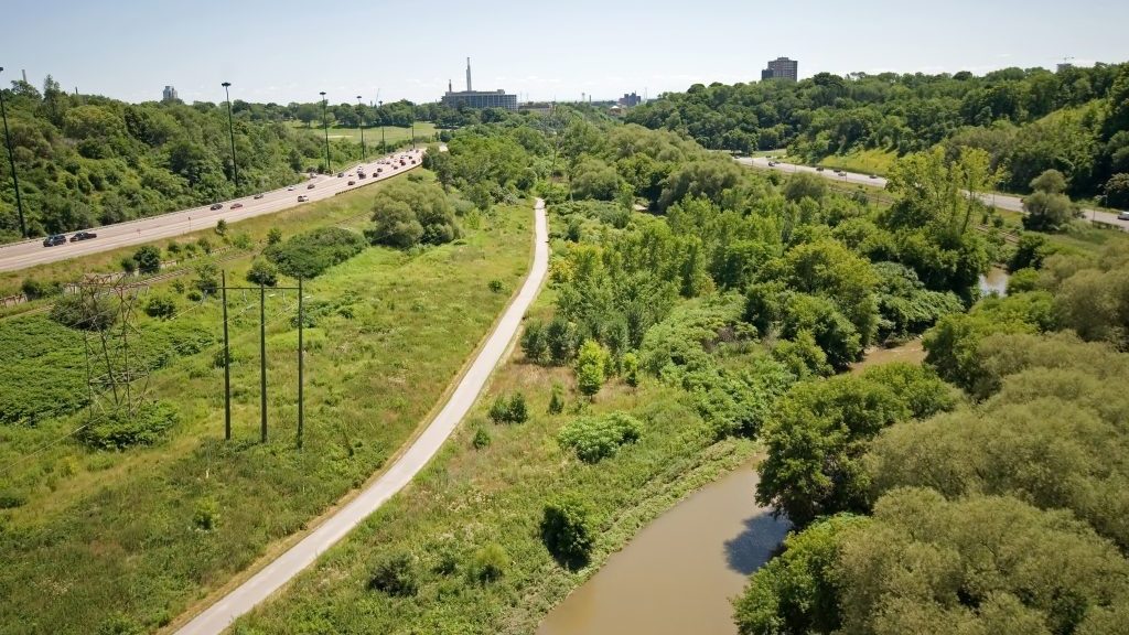
The long-abused Don River, its valley and now its mouth are finally closer to finishing a makeover three generations in the making.
The $1.25 billion Port Lands Flood Protection Project is on time, on budget and as spring arrives moving into the next phase to redirect Toronto’s east side river for a more controlled outflow while also taking steps to prevent flooding during extreme weather events.
It’s a feat of environmental engineering decades in the making and long overdue for the river and the Don Valley. The latter was perhaps the first phase in the city’s awakening when the much-maligned Don Valley Parkway started construction to link downtown to the exploding suburbs.
The plan, says David Kusturin chief project officer, is to re-engineer the river’s lower reaches to protect the Port Lands, South Riverdale and Leslieville.
He calls it the biggest infrastructure project in Toronto’s history, a key piece in the plan to turn the toxic brownfields into a mixed-use community with 240 hectares for development on lands which were previously unattractive to investors.
“Winter was pretty good and progressing quite well,” he says. “The first project was the Cherry Street lakefill which started in 2017 and we’ll have full completion to meet the sunset date on the federal and provincial funding. We’re working on the cut-off walls for the river now.”
There are a lot of moving parts to the Port Lands, in all 23 separate and individual projects with the main one being the river valley piece, he says.
“There are marine and flood protection parts, three brand new spectacular and artistic bridges now under construction in the Maritimes and a rebuilt bridge,” he says.
Much of the infill and reclamation work around the port lands has been done and the Don Roadway and Commissioner’s Street are closed for excavation of 1.5 million cubic metres of soil and to raise the grade level to defend against flooding.
One day there could be a storm that sends water cascading down and we don’t want the river to wash the entire Port Lands away,
— David Kusturin
Port Lands Flood Protection Project
At the same time, it will allow crews to install services like water, sewage, stormwater and other utilities that are nonexistent and doing so make the land more attractive for development.
“The contract for the river was broken into two and we’ve been working on the cut-off wall since last summer and will continue on for month or so,” he says. “We’re creating a concrete wall set on caissons in bedrock which are anywhere from 12 metres deep to 55 metres deep.”
The wall will support the excavation of the land to prevent the soil collapsing and slumping back in and keep the lake out as the excavated area is dewatered so they can dig out the new river channel in a relatively dry area.
The wall will also keep the contaminant endemic to the Port Lands from seeping into the river and ultimately Lake Ontario. The excavation will then be capped with a bentonite-clay layer to seal it off when the river water is diverted into it. Certain areas may be augmented with a membrane as well, he says, and some areas will get a sand-charcoal mix for filtering.
“If any contaminants do get through in those areas, the charcoal will deal with it,” he says.
It’s commonplace, tried and tested technology, he says, but innovative in terms of how and where it’s being applied and at the scale it’s being applied.
In researching the engineering it became apparent that contractors were familiar with the existing technology because it’s applied every day in downtown high rises.
“We looked at other solutions not as ubiquitous as this but it was much more difficult to find contractors equipped or experienced with them,” he says. “The bids were much more competitive and we used proven methods in an innovative way.”
One of the big issues with the Don River is the hard-right turn into the Keating Channel which restricts flow and the resulting build-up of pollution, sediment and debris and triggers flooding. It also makes it unlivable for the 21 species of fish and animals in the river along with scarce fertile ground for plants and trees.
To mitigate this, a meander — banked turns — will also be built into the new river flow, using a design theory drawn from fluvial geomorphology (the study of water course flow) to slow down the water, especially in peak times.
“There’s quite a bit of engineering which has gone into the design to keep the banks structurally stable,” Kusturin says. “We’re designing this because one day there could be a storm that sends water cascading down and we don’t want the river to wash the entire Port Lands away. We’re using armour stone and other products at those locations.”
The design parameters assume kinetic energy during peaks to approach the speed of Niagara Falls with just less than half the volume, he says.


Recent Comments
comments for this post are closed