According to a World Economic Forum report on innovation in construction, digital integration in the ICI sector will drive annual global savings of more than $1 trillion and drones will be front and centre in the evolution.
“During the actual construction phase, drones survey and inspect the construction site. 3D printers prefabricate many of the building components. GPS and radio-frequency identification (RFID) are used for tracking the materials, equipment, and workers, in order to then optimize flows and inventory levels. Robots and autonomous vehicles do much of the actual building work. 3D laser scanning or aerial mapping is used for comparing work-in-progress against a virtual model, thereby enabling prompt course corrections and minimizing corrective work,” write authors of the 2016 report, Shaping the Future of Construction. “Take the case of a Japanese equipment manufacturer that has developed fully autonomous bulldozers, led by drones that map the area in real-time to provide data on the workload.”
And that’s just what Canadian entrepreneurs The Sky Guys, a professional drone service based in Oakville, Ont. serving clients around the world, is seeing happen already.
COO Tom Hanson says not only is the construction sector one of many sectors the company services but it is also one of the fastest growth areas for drone use.
Sky Guys started out as a marketing service for real estate in 2016, he says, and then saw other opportunities as other digital-driven technologies became smaller, lighter and more able to be integrated into a drone’s payload.
The service has gone far beyond just providing eye-in-the-sky video and photographs for clients and is now being used to map, scan soil conditions with LIDAR, look for water leaks, capture topography and integrate with BIM to chart progress and synchronize project management timelines.
“Now we’re focused on construction, real estate, power utilities, engineering, mining, agriculture and military applications,” says Hanson. “We’re number one in Canada and among the top 20 companies in the world.”
The business opportunities grew with the technology and the expanding capabilities of digital hardware and the attendant software, he says, to the point where Sky Guys also provides data services for clients, analyzing and extrapolating key data point from the raw data.
Hanson says the business now includes designing and building the UAVs, the related hardware, as well as work on the software and data collection and analytics side.
“We provide actionable insight to improve existing project management,” he says. “We’re providing a turn key solution as opposed to just going out and collecting the data.”
“We provide actionable insight to improve existing project management and work flows, to help them stay on time, on budget” he says. “We’re providing a turn key solution as opposed to just going out and collecting the data.”
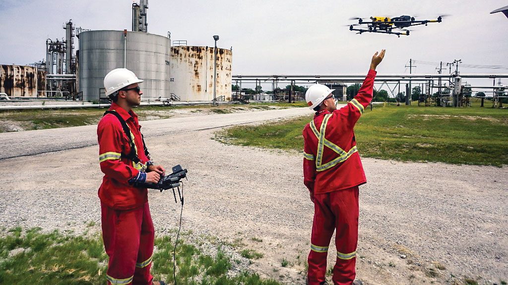
UAVs can quickly survey building sites and generate maps or plans. Once the GPS locator points are laid in at a site and programmed into the flight path, it’s a simple task for a crew to fly the same pattern at intervals to track progress, says Hanson.
That’s a plus for developers who don’t have to rely on cumbersome machinery and expensive surveying tools or shut down sites for safety reasons.
Other technologies like VR and augmented reality engage stakeholders and clarifying design ideas. Finally, they can reduce the time operators and surveyors spend in high-hazard areas, which in turn is a health and safety bonus, say experts.

Sky Guys has about 75 ongoing and active projects at any given time both in Canada, the U.S. and around the world, ranging from residential and condo developments to civil projects such as dam, roads, bridges and railways.
“It’s really endless,” he says. “With BIM for example we can track progress and render 3D models, we can check earthworks by depth to ensure it’s on schedule and we can look for environmental encroachment, such as a leak in a mining tailing pond.”
The flight regulations vary by jurisdiction with Canada having one of the strictest regimes. Flying in Saudi Arabia, for example, is much different than piloting a UAV at construction site in Toronto.
For tight downtown sites UAV work may not be possible because of those restrictions. Hanson says they won’t fly unless they can comply with regulations and always does a site check to look for overhead wires and other structures which may cause issues.
They have a network of 100 pilots qualified to fly the UAVs, some working as contractors and some on staff. Depending on the nature of the job, they will either contract out or send a staffer for the more complex, delicate assignments. A crew consists of a pilot and a spotter who is required to maintain a line-of-sight on the UAV at all times even though the pilot may have a POV (point of view) from a video screen in front of him.
“A lot of companies start out doing it in-house and quickly realize it’s more complex than they thought it was,” says Hanson. “Then they call us.”
Recent Comments
comments for this post are closed