Technology created by Canadian company vGIS to allow utilities to easily locate and visualize underground infrastructure is finding new users among construction companies who want to create an accurate record of new construction and visualize finished structures prior to completion.
“The biggest challenge for municipal clients is to effectively utilize their workforce to avoid costly delays or infrastructure damage during the infrastructure locate process,” says vGIS founder and chief executive officer Alec Pestov. “For example, our technology was adopted by a client after a single incident when a damaged water pipe caused $1.2 million in damages.”
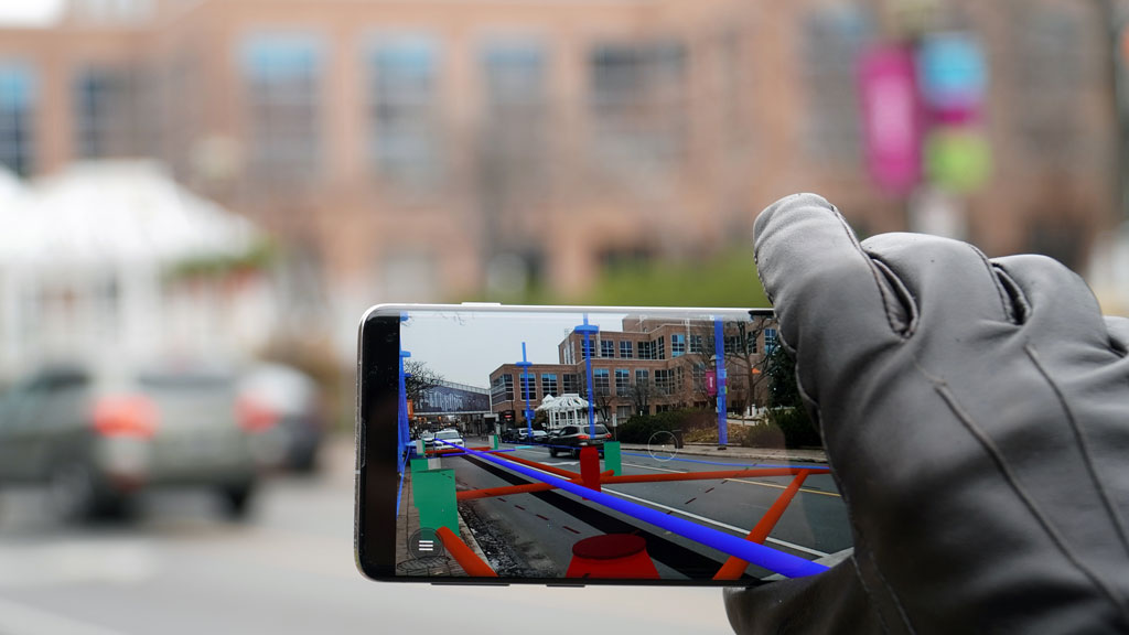
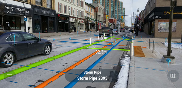
The technology allows the user to place the device in front of any location and then visualize an overlay of every type of underground infrastructure, relying on the client’s own GIS data. Infrastructure representations are colour-coded to distinguish fibre optic lines from electrical conduits and sewer and water pipes.
Initial versions of the technology, first prototyped in 2016, used the 3D technology of Microsoft HoloLens eyewear.
“The 3D view is best for quickly determining the relative size and depth of objects,” says Pestov. “Later versions of vGIS began to leverage the 2D augmented reality capabilities of tablets and smartphones.”
While the technology first gained traction with municipal clients around the world — including the City of Toronto, the Region of Peel and the City of Los Angeles — the ability of the technology to incorporate BIM, added in 2019, has seen rapid uptake of vGIS by engineering and construction companies, such as Stantec, Atkins, Skanska and the U.S. army Corps of Engineers.
“We can now aggregate data from multiple sources into a single, unified view not only to see what’s already there but also to see into the future and perceive what the structure will look like once built,” says Pestov. “The technology can leverage augmented reality to view all aspects of building construction above ground as well.”
The user can choose to view any source of data, from GIS, BIM and architectural drawings to survey plans, either simultaneously or one at a time. A user could, for example, view only the foundation and every point the sewer or water infrastructure enters that foundation.
vGIS is also being used for reality capture, allowing users to employ their smartphones or tablets to capture information on projects, such as a pipe trench they’ve excavated, using video or LiDAR.
“You can record the exact location of the pipe as placed into the trench,” says Pestov. “vGIS will geo-reference that trench, import the BIM data associated with it and convert it into a model that can be used for downstream analysis. You can also record construction of that pipe over time. The information can be used to confirm construction details and later be provided to the building owner.”
A recent project employing vGIS reality capture involved the construction of a railroad crossing, allowing the contractor to record the exact locations of trenches, rebar, gravel, electrical conduits and concrete to centimetre-level accuracy.
Pestov notes the information could later be used to present 3D images of the project and travel backwards through time to the project’s beginning.
vGIS is offered according to a software as a service model, with clients paying $95 per month for the first connected device, based on an annual contract, with discounts offered for additional devices. Clients can choose to import data themselves using a web-based front end or contract vGIS to provide onboarding assistance.
“We’re seeing primary contractors now providing vGIS service to all of their subcontractors working on the project,” says Pestov. “They find it beneficial for everybody to work from the same model.”

Recent Comments