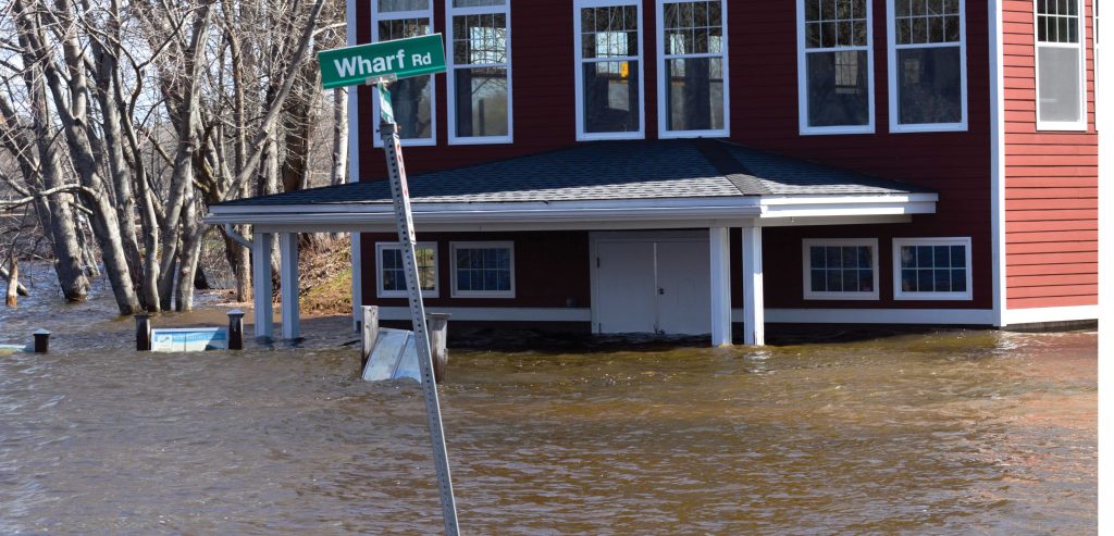
As a winter without end finally gives way to warm spring temperatures, rivers choked with ice and swollen with runoff are causing floods in many parts of Canada.
At the beginning of May, parts of Alberta, Quebec, Ontario, British Columbia and, especially, New Brunswick were under water.
As soggy as the situation is now, many regions of Canada are likely to experience more flooding in the future, says Shawna Peddle, director of Partners for Action in the University of Waterloo’s Faculty of Environment.
“There are many reasons,” said Peddle.
“For example, changing weather patterns and an increase in the number of storm cell events. In addition, there is more and more development and paving-over of formerly empty ground, so there are fewer wetlands to absorb run-off.”
On top of that, says Peddle, much of Canada’s water infrastructure is old and out of date, and unable to handle the increased water volumes caused by up-stream development.
Although some regions of the U.S., such as the lower Mississippi River valley, and some countries, such as the Netherlands, are more often under water than Canada, flooding is still the number one cause of insurance and personal losses in this country.
“Most people remember such major floods as Winnipeg in 1950 and 1997, and Calgary in 2013, but they might not know that every province experiences flooding each year,” said Peddle.
“Some of the floods take place in rural areas where relatively few people are affected, and those events might not make the news.”
Although no city or region can be made 100 per cent flood-proof, the risks of a good soaking can be reduced in a number of ways, says Peddle.
Examples include upgrading water-related infrastructure, updating building codes and encouraging closer inter-jurisdictional cooperation.
“Measures can be taken at all levels,” she said. “Everybody has a role to play.”
Another measure the country could take to keeping dry is to equip itself with up-to-date flood maps, says Tamsin Lyle, principal engineer at Ebbwater Consulting Inc. in Vancouver.
According to a report of the National Floodplain Mapping Assessment commissioned by Public Safety Canada, the country has mapped the geography of only 28,000 kilometres of waterways.
And although some provinces use once-in-100-years as the flood-risk standard, others use a more conservative once-in-500-years yardstick.
“The risks of flooding in many parts of Canada are growing because the country is growing and people and buildings are being added to vulnerable flood plains every year,” said Lyle.
While there are certainly benefits to living in cities that happen to be located on flood plains, there are also costs, and we need to become more conscious of them and take them into account as we build our cities, she says.
“And when we’re designing our solutions, we need to consider all of the potential natural disasters that could happen in the area, so that we don’t inadvertently worsen the fall-out from another kind of catastrophe,” Lyle said.
“We could, for example, put buildings on stilts, to keep them above water in the case of a flood. But those buildings could collapse if an earthquake struck.”
Dave Murray, a principal and water resource engineer in the Victoria office of consulting engineers Kerr Wood Leidal Associates Ltd., says Canada should look abroad for ideas on flood mitigation.
“We need to study the Netherlands’ Room for the River flood plain management program,” Murray said.
Keeping their heads above water has been a preoccupation of the Dutch since people started settling on the marshy soil near the North Sea.
Two-third of the Netherlands is below sea level. And the rivers which flow through the country on their way to the ocean overflow regularly.
In 1993 and 1995, severe flooding resulted in mass evacuations and left thousands of acres of farmland under water.
As a result, the Dutch government developed a program that enabled the rivers to safely handle greater volumes of water than in the past.
This was a major shift in Dutch flood mitigation thinking.
Before the 1990’s floods, the Netherlands relied primarily on dikes and berms to keep flood waters at bay.
The Dutch program creates “room for the river” in a number of ways — increasing stream depth, storing water, relocating dikes, creating high water channels, and lowering into the river structures that disrupt water flow.
The program allows land lying along rivers to act as natural water sponges in the event of a flood.
Since it was developed, the Dutch have taken the Room for the River program to other countries, including the Philippines.


Recent Comments