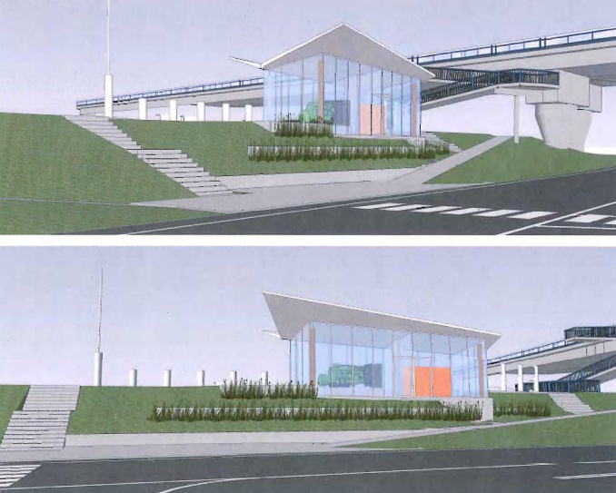
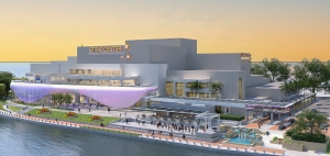
A unique water pumping station is nearing completion in Richmond, B.C., a Vancouver suburb that happens to be surrounded by water.
Belying its plain Jane moniker – the Number Two Road Pump Station – the structure’s see-through glass walls and its location near the busy Vancouver International Airport will make it an unusual visual gateway to Richmond.
Located on the Fraser River at the north end of Number Two Road, a major north-south Richmond artery, the station is operational now.
Its glass walls and landscaping are expected to be completed in the early summer of 2018, about two years after work on it started.
“It’s an important location,” said Simon Kras, a project engineer with engineering consultants WSP, which acted as contract administrator and professional-of-record for the civil, mechanical and electrical portions of the work. “A highlight structure for the city, the pumping station will naturally attract attention.”
Its glass walls will give the station a public information component, Kras said.
“The transparent walls mean people can see inside,” he said. “They create greater interest in the station and its activities than if they were solid.”
The new station will be able to pump 4,700 litres/second, about twice the capacity of its predecessor.
It is WSP’s third upgrade of a Richmond pumping station.
Kras said the new Number Two Road station has a number of post-disaster structural features, such as a buried cable vault and allowance for 0.9 metres of differential movement, in case of an earthquake.
Installing the pumping equipment was routine, but the rest of the project was complicated, he said.
“It has a complex design, with a wing-shaped roof and glass walls,” Kras said. “Because of the transparent walls, the mid-summer cooling requirements are significant.”
The architecturally-striking building is a replacement for a pumping station that was built in the mid-1970s.
“An increasing number of municipalities are going the Richmond route, enhancing municipal infrastructure with architecture components,” said Gurjit Sangha, WSP’s vice-president of water and wastewater infrastructure. “For example, Richmond has added landscaping and invited city school children to contribute their artwork for the exteriors of the stations.”
Including the Number Two Road station, Richmond has 39 drainage pump stations.
“They’re all around Richmond at the ends of major roads, approximately one mile apart,” said Milton Chan, Richmond’s manager of engineering design and construction. “The pumping stations take in rainwater. At low tide, gravity takes the water away to the Fraser River and the ocean, and at high tide the stations pump the water out.”
The stations, which were built 40 to 50 years ago, are being rebuilt gradually according to Richmond’s Official Community Plan’s forecast of future pumping needs.
“More pumping capacity is needed in the city because it is growing so big and so quickly, and built-on land is less capable of absorbing water,” said Chan.
In addition to its network of pumping stations, Richmond has a system of dikes that encircle the city.
Because the land on which Richmond is built averages just one metre above sea level, it is prone to flooding, especially during high tide.
Richmond has approximately 50 kilometres of dikes, said Lloyd Bie, Richmond’s acting director of engineering, which protect the city from its surrounding waters.
Consulting engineers Kerr Wood Leidal (KWL) are working on dike master plans for three areas of Richmond that will provide a blueprint for dike upgrading activities by the city.
“A key challenge with this work is the need to address anticipated sea level rise,” said Mike Currie, KWL principal and senior water resources engineer. “As with most other diking authorities, the city is planning to accommodate one metre of sea level rise to the year 2100. That means raising the dikes to an elevation of about 4.7 metres, compared to the previous design elevation of 3.5 metres.”
In addition to meeting the expected rise in the sea level, raising the dikes allows for 0.2 metres of land subsidence.
“Raising the dikes by over one metre will involve considerable earthwork, relocation of drainage ditches and modification of infrastructure,” Currie said. “Measures to protect the dikes against seismic events are also being considered.”
Currie said some of the dike works that are needed will be “very innovative” compared to traditional earth dike works.
“This may include, for example, an offshore dike at Steveston (in southwest Richmond) that includes harbour gates,” he said. “We’re also considering wave mitigation works on the west side of Richmond.”
Whatever form future dike work takes, it will have to accommodate public access along the foreshore, as well as sensitive environmental conditions in the riparian zone, Currie said.


Recent Comments
comments for this post are closed