NEW ORLEANS, LA.—The Mississippi River and Tributaries (MR&T) project is the largest flood control project in the world and represents one of mankind’s most successful civil works undertakings, states the U.S. Army Corps of Engineers New Orleans District.
Providing protection to the 36,000-square-mile lower Mississippi valley, the project has a historic past and was authorized through the Flood Control Act of 1928. It’s meant to control a "project flood" which is the largest flood that’s reasonably expected to occur.
Throughout its storied past major floods have occurred along the Mississippi with the most disastrous in the history of the lower Mississippi valley occurring in 1927. Affecting about 26,000 square miles, the flood resulted in breached levees, and cities, towns, and farms were destroyed. A solution was needed to mitigate future flooding. Thus, the MR&T project was conceived.
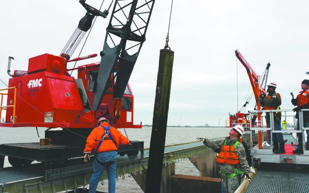
While the MR&T project is performing as designed, it is still very much an active operations and maintenance plan, which often involves updating and upgrading the existing infrastructure, explains Mike Stack, chief of emergency management with the U.S. Army Corps of Engineers New Orleans District.
"You think of it as kind of a living project. After you construct features, over time, as the river changes or as conditions change, those features need to be adjusted to account for that," he explains. "There are a lot of parts to the MR&T project itself. There’s the original construction and then there’s operations and maintenance."
There are four major elements of the MR&T project: levees for containing flood flows; floodways, which are passages for excess water flows; channel improvement and stabilization; and tributary basin improvements for major drainage basins, which include dams and reservoirs, pumping plants, auxiliary channels and pumping stations.
According to the Corps, since the initiation of the MR&T project, the U.S. has received a $45 return for every dollar invested, which to date is around $14 billion, says Stack.
According to the Corps, the levee system, which is constructed of compacted soil and clay, rivals in length the Great Wall of China and protects more than four-million citizens.
The main stem levee system, comprised of levees, floodwalls and various control structures, is 2,203 miles long — 1,607 miles lie along the Mississippi River itself, the Corps explains.
Constructed by the federal government, the levees are maintained by local interests, but the government provides assistance during major floods. Inspections and maintenance are conducted by the Corps of Engineers and the local levee and drainage districts.
"The MR&T’s been under construction since the 1927 flood so over time levees themselves settle and you have to go back and raise them," Stack explains, adding that’s the bulk of the remaining construction work. "There’s also structures that were built early on in the project that are now, because of settlement and other reasons…what we call deficient."
The stabilization of the riverbanks is also important for flood control, and various measures are taken to ensure "the desired alignment of the river’s navigation channel," the Corps explains.
Just recently the measures of the MR&T project were put into use when water levels along the Mississippi started to rise. The U.S. Army Corps of Engineers was spurred into action combating the high levels in what’s called a flood fight.
"What happened this year was kind of unusual: We had a large flood on the system, which led to a large flood fight," Stack explains. "We’ve had a warm winter, there’s been a lot of rain."
This flood fight began in December and continued into January. Flood fights are triggered when the Mississippi rises above 11 feet.
"Whatever size predicted flood is coming our way, the flood fight program is designed to go out there and make sure the system can safely pass that," explains Stack. "We have different triggers when the river gets to 11 feet in New Orleans. We go out and start doing flood fight inspections. If we were to find anything…then we would take some action to flood fight it, which is basically preventing it from getting worse or preventing it from becoming a problem for the levee system."
Sometimes during a flood fight, construction activity in close proximity to the levees is halted, Stack adds. This is because the Corps and State of Louisiana have established allowable distances for certain types of work.
"The river itself runs through some very heavily populated, heavy industrial-type areas through Baton Rouge and New Orleans," he says. "So there’s a lot of construction activity, things that businesses are doing, or that these industrial plants are doing, that we need to keep track to make sure that activity doesn’t comprise the integrity of the levee."
During this flood fight, the Bonnet Carré Spillway was opened in order to divert water away from New Orleans, which for this time of year was unique, Stack says.
"The Louisiana portion of the system is really about taking the water that’s been collected on the way down and safely passing out to the Gulf of Mexico," says Stack. "It’s (the Bonnet Carré Spillway) another outlet if you will that allows us to control really how much water is passing through the city of New Orleans through the levee system."
The river has since fallen back below 11 feet in New Orleans and Stack says the recent event is just another example of how the MR&T project works effectively.
"We look at it as one of most successful civil works projects in the Corps of Engineers and the country," he adds. "Although it’s a very large investment to put a system like this in, the benefits in flood damage reduction and reliable navigation, those kinds of things have paid off very well over the years."


Recent Comments
comments for this post are closed