 admin
admin
They called it Duff’s Ditch even before construction began. The term was used pejoratively, ridiculing Dufferin (Duff) Roblin, who championed the construction of the Red River Floodway, first as leader of the opposition in the provincial legislature, then as premier.
The idea was simple. Build a great big ditch leaving the Red River south of the Winnipeg, looping around the city’s east end, and rejoining the river north of the city.
The construction of the floodway, along with related works on the Assiniboine River, would mean a capital expenditure of more than $72 million, amortized over 50 years at four per cent interest, at a time when the province had a total population of only 900,000 and annual net provincial revenue of about $74 million.
Manitobans were strongly divided and Duff’s Ditch became a sort of shorthand for a huge project built at great expense with the dubious hope of preventing future flooding.
Winnipeg had had a disastrous flood in 1950, its first in almost a century, and both provincial and federal government had come to think of flooding as a purely local concern.
But the Red River has a long history of misbehaving occasionally. In the area’s recorded history, there had been devastating flooding three times. There had been lesser flooding on an average of once every 10 years.
In May 1826, for example, flood waters rose to a height of almost 11 metres above the winter ice level in the river, and covered much of the area Winnipeg now occupies in up to 4.5 metres of water.
But that was a long time ago, and by the time the 1950 flood struck, the city had virtually no flood defences.
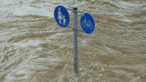
More than 10,500 homes were inundated in Winnipeg. More than 100,000 people had to evacuate. The flood waters rose more than nine metres and formed a lake south of the city that was 120 kilometres long and 39 kilometres wide. More than 1,450 km2 of southern Manitoba was flooded, forcing the thousands of rural residents from their homes.
It may be difficult to imagine, but the river remained above flood stage for 51 days. For 10 of those days, the flood waters were within 40 centimetres of topping the sandbag dikes and flooding the entire city core.
The dikes held and the city centre escaped, but it remains one of Canada’s great natural disasters.
We now know that building on a flood plain is unwise. But much of southern Manitoba is one gigantic flood plain. It’s in the basin of Lake Agassiz, a shallow glacial lake that covered the area during the Pleistocene era, which lasted from about two million years ago until about 10,000 years ago. The basin is one of the flattest parts of North America, and slopes northward, but very gradually, only a few centimetres per kilometre. It’s drained by the Red River.
To make matters worse, the soil is made up of a thick deposit of silt and a heavy clay, locally famous as "Manitoba gumbo." And it doesn’t absorb much water when it rains. Roughly half the rain runs off instead of being absorbed, as it is in the lighter soils found farther to the west.
The Red is a shallow river, between three and nine metres deep when it’s filled to the top of its banks.
After the 1950 flood, the federal government undertook a hydrological study, and its 1953 report (which ran to nine volumes) contained preliminary plans for what was to become the Red River Floodway to augment a system of dikes.
The study also included the Assiniboine, which rises in Saskatchewan and meanders south and east and joins the Red in the centre of Winnipeg, in an area known locally as The Forks.
The Assiniboine doesn’t usually cause as many problems. Where it rises is in an area of drier climate and sandier soil. Still, it can cause problems occasionally.
That’s why the study recommended a 27 kilometre diversion channel from Portage la Prairie north to Lake Manitoba to divert the flood waters into the lake long before they reach Winnipeg. It also recommended a reservoir dam on the headwaters of the Assiniboine, near Shellmouth, Man.
But Premier Douglas Campbell wasn’t convinced. A cautious man, and a cautious politician, he waited, afraid of the cost. Finally, he appointed a provincial Royal Commission to assess the federal proposals.
The commission reported back late in 1958, recommending construction of the proposed floodway, the Portage diversion and the Shellmouth reservoir. It also recommended that a study be made of the feasibility and cost of a system of ring dikes around towns south of Winnipeg that would still face the possibility of flooding.
The three engineering projects were estimated to cost about $72.5 million. The floodway would take most of that at $57.4 million; the Shellmouth reservoir would cost $6.4 million, and the Portage diversion $8.7 million.
Roblin ran with the idea, even though many Manitobans were dubious, and began calling the project Duff’s Ditch.
But when Roblin won the a provincial election and formed a new government in June, 1958, he kept promoting the idea, and eventually got a commitment from Prime Minister John Diefenbaker to pay up to 60 per cent of the construction costs.
Roblin acted quickly, and planning began almost immediately. But it was a complex project that needed studies of soil mechanics of the Manitoba gumbo to ensure stability of the slopes of the ditch. There would need to be a lot of excavation, so work would need to be scheduled to minimize disruption of traffic or utilities. There would also be a lot of expropriation, especially at the north end of the floodway, where it would be crossing many small properties.
The floodway was designed to handle a flood of 3,965 m3 per second, divided between the river and the floodway, with the floodway channel having a design capacity of 1,700 m3 per second and the river channel having a maximum flow of 1,265 m3 per second.
After three years of planning, contracts were awarded in October 1962. It was completed on time in March 1968 at a final cost of $62.7 million. Ring dikes were also built around the towns of Emerson, Letellier, Dominion City, St. Jean Baptiste, Morris, Rosenort and St. Adolphe.
The so-called "flood of the century" in 1997 led the International Joint Commission to review flood protection measures in Winnipeg. The floodway handled the flood waters — just, and the commission was concerned.
The review led to an expansion of the exiting floodway, beginning in 2005. The $627-million expansion was funded jointly by the provincial and federal governments.
The work involved widening the channel from 35 metres to 85 metres. The hydraulic, mechanical and electrical equipment was upgraded and erosion protection around the inlet control structure was also upgraded. The outlet control structure north of the city was expanded to twice its size, adding erosion protection and building baffle blocks to reduce the speed of the water. Railway and highway bridges were elevated, and either replaced or upgraded.
As a result, the floodway channel, which had an initial capacity of 1,700 m3 per second, now has a capacity of 4,000 m3 per second, providing protection for one-in-700-year floods.
A footnote: During the flood of the century in 1997, a huge swath of the downtown core of Grand Forks, N.D., was inundated. It was later calculated that if Winnipeg hadn’t had the floodway that spring, the corner of Portage and Main in downtown Winnipeg would have been under four metres of water.
It wasn’t, thanks to Duff’s Ditch.


Recent Comments
comments for this post are closed